Autauga County Alabama Flooding
Autauga County floods in two ways. Along its southern edge, the Alabama River sets the county’s largest-scale flood exposure. Inside the county, creeks and poor-drainage neighborhoods flood much more often, usually after a few hours of intense rain, and Prattville sits at the center of that problem.
Flooding in Autauga County, Alabama: Flood Zone Map, History, Risk, and What to Do
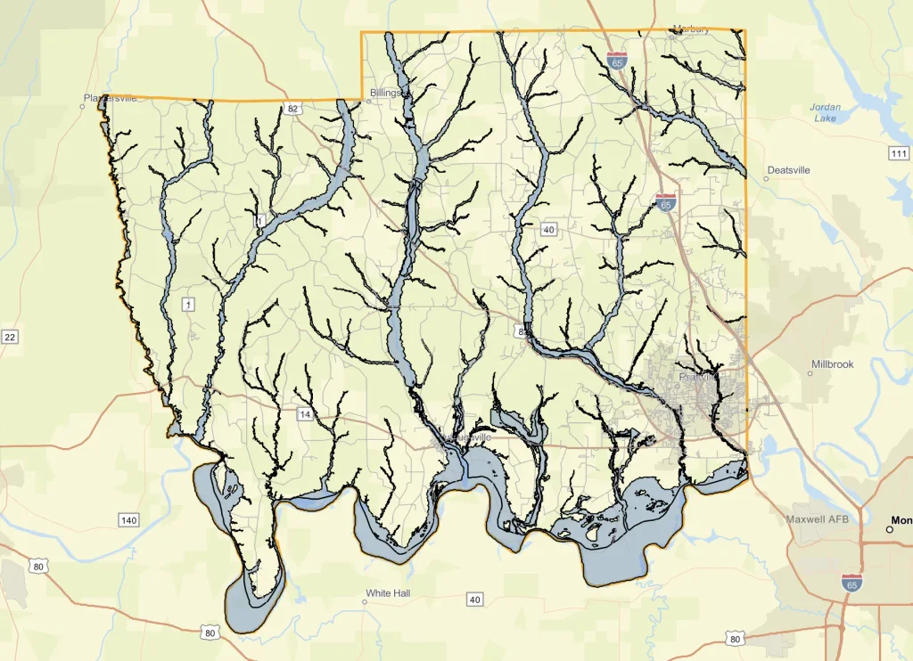
The county’s own floodplain page notes that it is bordered by the Alabama River and crossed by several large creeks. Prattville’s city floodplain page names the watercourses behind its flood hazard: the Alabama River, Autauga Creek, Fay Branch, Noland Creek, and Pine Creek, along with their smaller tributaries. Autauga Creek runs through the city, and Pine Creek is the stream beside the Candlestick Park mobile home community on South Memorial Drive, where firefighters carried out a flood evacuation in the early-2024 storm described below.
The highest documented risk is in southeast Autauga County and in Prattville itself. In the June 2017 flood, emergency management reported flooding concentrated in the southeast part of the county, including parts of Prattville. Smaller communities such as Autaugaville, Billingsley, Booth, Marbury, Mulberry, Vida Junction, New Prospect, and Dawson Mill regularly appear in National Weather Service flood warning text for the county.
Flood season here follows Gulf moisture. Heavy rain events have arrived in winter and spring, and the 2017 flood coincided with a tropical system moving into the Gulf. Central Alabama is also in a region where severe thunderstorms can drop several inches of rain in a few hours, which is the pattern behind most of the county’s flash flooding.
1A. Current Conditions and Where to Check Live Flooding
This page explains how to find live information. In an active emergency, follow official National Weather Service and county instructions and call 911.
To check conditions right now:
- The National Weather Service forecast office in Birmingham issues alerts for Autauga County. Its alerts appear on weather.gov when you enter the county or a Prattville ZIP code.
- USGS stream gauge pages show creek levels in real time at sites on Autauga Creek, listed in section 6.
- Prattville’s floodplain page links to Alabama River gauges, including the one at Montgomery.
- Autauga County Emergency Management, at (334) 361-3758 during business hours, publishes county-level notices.
Several alert types apply here. A flash flood warning means flooding is happening or about to happen quickly after intense rain. A flood warning covers flooding on rivers and streams. An areal flood warning, which the Birmingham office has issued for this county, covers flooding that develops over a longer period of heavy rain and often persists after the initial flash flooding. A flood advisory covers lesser flooding that is still a nuisance and can be dangerous on roads.
2. Flood History and Notable Events
Autauga County’s flood record is a series of heavy-rain events that overwhelmed local creeks and drainage. Five stand out in the sources reviewed for this article.
May 6–8, 2009. A presidential disaster declaration issued June 3, 2009 covered severe storms, tornadoes, flooding, and straight-line winds. Autauga, Bullock, Elmore, and Montgomery counties were designated for Public Assistance.
March 9, 2011. The National Weather Service’s Birmingham storm data log for March 2011 lists a long run of flash flood entries for Autauga County between about 4 a.m. and 7:15 a.m. on March 9. The log excerpt reviewed does not describe impacts for each entry.
December 23–31, 2015. Severe storms, tornadoes, straight-line winds, and flooding led to FEMA-4251-DR, declared January 21, 2016. Autauga was among the counties approved for Public Assistance.
June 18, 2017. Over five inches of rain fell northwest of Prattville and more than three inches fell across a wide area, according to a local report. The Prattville Airport recorded 5.69 inches, compared with 3.26 inches at Montgomery’s airport. Emergency management reported up to 17 roads flooded and impassable, especially in southeast Autauga County. The Birmingham office issued an areal flood warning, and the NWS storm data log lists flash flood entries for June 18.
Early 2024. Overnight storms brought widespread street flooding in Prattville and a flash flood warning with expected rainfall above five inches. Prattville firefighters, including the swift water rescue team, rescued 13 people and six animals from homes in the Candlestick neighborhood near South Memorial Drive. Mud covered downtown streets near West Main and Court streets, and Autauga County Schools delayed opening by two hours. The coverage reviewed did not give the calendar date in the excerpt; the editor should confirm it.
2A. Flood Timeline and Measured Data
| Date | Cause and measured data | Communities and places affected | Source |
|---|---|---|---|
| May 6–8, 2009 | Severe storms, tornadoes, flooding | Autauga, Bullock, Elmore, Montgomery counties (Public Assistance) | White House declaration, June 3, 2009 |
| March 9, 2011 | Heavy rain flash flooding; many flash flood entries from about 4 to 7:15 a.m. | Autauga County zone | NWS Birmingham storm data, March 2011 |
| Dec. 23–31, 2015 | Storms, tornadoes, straight-line winds, flooding | Autauga among 39 declared counties | FEMA-4251-DR, declared Jan. 21, 2016 |
| June 18, 2017 | Over 5 in. NW of Prattville; 5.69 in. at Prattville Airport; up to 17 roads flooded | SE Autauga County, parts of Prattville | NWS Birmingham warning text; local weather report; NWS storm data |
| Early 2024 (date to confirm) | Overnight storms, forecast rainfall above 5 in.; 13 people and 6 animals rescued | Candlestick neighborhood (South Memorial Dr. near Autauga County 4, near Pine Creek); downtown Prattville | Montgomery Advertiser; Elmore-Autauga News |
Federal disaster declarations that included Autauga County are not all flood declarations. A January 15, 2023 declaration (DR-4684) covered severe storms, straight-line winds, and tornadoes from January 12, 2023, and made Individual Assistance and debris removal available in Autauga and Dallas counties. It is a storm declaration, not a flood one.
Past events shaped how Prattville and the county talk about drainage. After the 2024 flooding, the city’s Street and Drainage Committee met about standing water on Bent Tree Court, and a later meeting focused on road drainage in the Hilltop, Brandywine, and Candlestick neighborhoods. Those meetings show drainage, not just river flooding, is the day-to-day problem.
3. FEMA Flood Zones and Floodplain Management
Flood zone designations are set on FEMA’s Flood Insurance Rate Maps. This article does not list the specific zones present in Autauga County, because the zone data was not supplied for this edition and flood zone claims should come from the official map. Zones beginning with A are mapped high-risk areas, and Zone X covers moderate and minimal risk.
Floodplain management is split between the county and its cities. For unincorporated Autauga County, the Engineering Department publishes the flood regulations and permits, including a Flood Damage Prevention Ordinance, a Flood Damage Master Plan of Enforcement, a permit requirement page, and a permit application form. Anyone building a house or moving a mobile home into the county is told to call the Autauga County Engineer’s Office at (334) 361-3761 to check requirements for the location. For property inside Prattville, the city’s Planning Department handles floodplain development permits and keeps the Flood Insurance Rate Maps for inspection at 102 West Main Street.
Autauga County joined the National Flood Insurance Program, which makes flood insurance available to homeowners and renters. Prattville’s page states that flood insurance is available to any homeowner or renter in the city or county, and that you do not have to live in a designated flood zone to buy it. Whether any Autauga community participates in the Community Rating System could not be confirmed from the sources reviewed; residents can ask the county Engineer’s Office or Prattville’s Planning Department.
High-risk and moderate-risk zones affect people differently. Homeowners with federally backed mortgages in a high-risk zone are generally required to carry flood insurance. Renters can buy contents coverage regardless of zone. Businesses in high-risk zones face the same lender requirements as homeowners, plus permitting rules that can require elevation or flood-proofing for new construction.
3A. County Flood Zone Map: How to Read It and Where to Find It
Autauga County Emergency Management’s page links to a Flood Zones Map, an interactive ArcGIS map. It is the county’s own tool for looking up a property, and it is the first place to look.
To check a specific address:
- Open the Flood Zones Map from the Autauga County EMA page at autaugaco.org.
- Enter or locate the property and note the zone shown.
- Cross-check on FEMA’s Flood Map Service Center at msc.fema.gov, searching by address. FEMA’s tool shows the effective map panel.
- If the property is in Prattville, ask the Planning Department at 102 West Main Street to confirm the zone from the Flood Insurance Rate Map. For unincorporated land, call the Autauga County Engineer’s Office at (334) 361-3761.
- To keep a record, print a FIRMette, a small-area printout of the effective map, from the Flood Map Service Center.
| Zone group | What it means | Where it appears in Autauga County |
|---|---|---|
| A and AE | Mapped high-risk, Special Flood Hazard Area; insurance usually required with a federally backed mortgage | Check the county map; floodplains of the Alabama River, Autauga Creek, Pine Creek, and other creeks are the usual locations |
| X (shaded) | Moderate risk | Check the county map |
| X (unshaded) | Minimal mapped risk | Check the county map |
The estimated share of the county in the Special Flood Hazard Area is not stated here. Flood map revisions do occur: a December 2014 Federal Register notice finalized Letters of Map Revision affecting Autauga County and the City of Prattville, with the Autauga County Emergency Management Agency at 826 Gillespie Street listed as a map repository. The current effective date of each panel should be confirmed on the Map Service Center. Whether any part of the county still relies on older paper maps is also not confirmed.
If a property is mapped incorrectly, a Letter of Map Amendment (LOMA) can remove a structure that sits on high ground from a high-risk designation, and a Letter of Map Revision (LOMR) changes the map itself. An Elevation Certificate, prepared by a licensed surveyor, documents a building’s elevation and is often needed for both a LOMA request and an insurance quote. Prattville’s page lists LOMAs and LOMRs among its floodplain management resources.
FEMA maps show regulatory risk for insurance and permitting. They do not show every place that can flood. Candlestick Park and downtown Prattville flooded because heavy rain overwhelmed creeks and drains, and a property outside a mapped high-risk zone can flood in the same way.
4. Emergency Response Agencies and Their Roles
Autauga County Emergency Management coordinates the county’s response agencies, including the Sheriff’s Office, fire departments, and police departments, and writes the plans that let them work together. The agency is at 826 Gillespie Street, Prattville, AL 36067. Its listed hours are Monday through Friday, 8 a.m. to 4 p.m., with an after-hours number of (334) 361-4840. The main number is (334) 361-3758. The county website lists David Bagley as EMA director at the time of writing; confirm before publishing, since staffing changes.
In Prattville, the fire department operates a swift water rescue team, which carried out the Candlestick evacuation. The Prattville Police Department urged drivers to stay off flooded streets during that event. State-level support comes from the Alabama Emergency Management Agency. The county’s Engineering Department handles road drainage and permits on county roads.
How the county activates its Emergency Operations Center, what triggers it, and who staffs it are not described on the public pages reviewed. Residents and reporters can request the county Emergency Operations Plan from the EMA office.
Mutual aid in this region typically runs through neighboring counties and the state. Neighbors named alongside Autauga in recent flood warnings include Elmore, Montgomery, and Lowndes counties. The specific agreements and conditions are not published in the sources reviewed.
The National Weather Service office in Birmingham serves Autauga County. It issues flood watches, flash flood warnings, areal flood warnings, and flood advisories, and the warnings list the specific towns and landmarks at risk.
5. Emergency Communications — Dispatch, Radio, and Alerts
Alabama’s statewide interoperability network is the Alabama Wireless Interoperability Network, known as AWIN. Which radio bands and talkgroups Autauga County agencies use for flood operations is not publicly documented in the sources reviewed, so this section describes functions rather than specific channels. Flood operations in a county like this typically involve a fire dispatch talkgroup, an emergency management operations talkgroup, and a state or regional mutual aid channel.
When a caller reports flooding to 911, dispatchers generally collect the exact location and cross street, whether anyone is in the water or in a vehicle, the water depth and whether it is moving, and whether there are hazards such as downed power lines. The call is then assigned to fire units, and if there is a person in moving water, a swift water team is requested.
Wireless Emergency Alerts reach phones in a warned area automatically, with no sign-up, when the National Weather Service issues a flash flood emergency or other qualifying alert. Residents can also sign up for local notifications. Which notification platform Autauga County uses was not confirmed, so residents should ask the EMA office or check the county website.
The following is an illustrative scenario, not a recorded transmission, and the unit names are invented for the example:
“Dispatch: Swift Water 1, respond to South Memorial Drive at Autauga County 4, caller reports vehicle in high water near Pine Creek, occupants on the roof, swift water team requested. Confirm access from the north. Units responding: Swift Water 1, Engine 2, Rescue 1, Sheriff’s unit for traffic control.”
6. Flood Warning Systems and River Gauges
USGS operates gauges on and near Autauga Creek. Sites listed in its monitoring system include Autauga Creek adjacent to U.S. Highway 82 near Prattville (02420400), Autauga Creek at County Road 20 near White City (02420268), Autauga Creek at County Road 63 near Booth (02420280), and a tributary to Autauga Creek at 3rd Street in Prattville (02420495). Which of these currently report real-time stage data should be checked on the USGS site before readers are sent to them. For the Alabama River, Prattville’s page links to gauges including the Montgomery gauge.
River stage matters because thresholds trigger action: when a river is forecast to reach flood stage, the National Weather Service issues a flood warning for the points it forecasts, and emergency managers use the predicted crest to decide on road closures and notifications. The Advanced Hydrologic Prediction Service is the National Weather Service’s river forecast tool. Residents can look up a forecast point on weather.gov. Autauga Creek’s small gauges do not have river forecasts, so the flash flood warning is the main alert for creek flooding.
Prattville’s floodplain page states that the Alabama EMA and the National Weather Service developed a flood warning system meant to provide up to one hour of advance warning of a flood hazard.
Alert types, in practice:
- Flood watch: conditions favor flooding; be ready.
- Flash flood warning: flooding is occurring or imminent; move to higher ground.
- Flood warning, including the areal flood warning: flooding is occurring or expected on rivers, small streams, or urban areas, and often continues for hours after rain ends.
- Flood advisory: minor flooding is expected that can still cause road problems.
Warnings for Autauga County usually list the places at risk, which helps residents recognize their location. Past warning text has named Prattville, Autaugaville, Billingsley, Booth, Mulberry, Marbury, Vida Junction, New Prospect, Dawson Mill, Autauga County Airport, and the Robert F. Henry Lock and Dam, along with neighboring places such as Millbrook, Coosada, Montgomery, and Maxwell Air Force Base.
The National Weather Service’s message is Turn Around, Don’t Drown. Most flood deaths nationally happen in vehicles, and a foot or two of moving water can carry a car.
7. High-Risk Roads, Bridges, and Infrastructure
The county does not appear to publish a list of roads that repeatedly close in floods, so this section sticks to places named in reporting.
South Memorial Drive near the Autauga County 4 intersection is the access route to the Candlestick Park mobile home community and was a rescue site in the early-2024 flood. Downtown Prattville, around West Main and Court streets, took on water and mud in the same event. Bent Tree Court, Hilltop, Brandywine, and the Candlestick neighborhood roads have been the subject of drainage meetings. In June 2017, emergency management reported up to 17 flooded and impassable roads, concentrated in southeast Autauga County; the roads were not named in the sources reviewed.
These locations are vulnerable because of proximity to Pine Creek and Autauga Creek and because of drainage in developed neighborhoods that lack enough capacity for several inches of rain in a few hours. The USGS gauges at Highway 82, County Road 20, and County Road 63 sit at creek crossings, which shows where the creeks meet roads, though gauge locations do not by themselves mark where closures occur.
Closures are communicated through county and city social media, school and utility notices, and local news. Drivers can also check the Alabama Department of Transportation’s traveler information for state routes. Barricades are placed by the county Engineering Department on county roads and by city crews inside Prattville.
The local Turn Around, Don’t Drown message was repeated by officials in the region during the 2024 event, as neighboring Elmore County’s emergency director urged drivers to turn around where water flowed across roads. This article did not locate a specific Autauga ordinance or state statute on driving past flood barricades; ask the Sheriff’s Office or Prattville Police about citations.
8. Flood Insurance — NFIP and Private Options
Because Autauga County and Prattville participate in the National Flood Insurance Program, residents can buy NFIP coverage through an insurance agent. Policies carry a waiting period, generally 30 days, before coverage starts, with limited exceptions such as when the policy is required for a new loan. The program covers up to $250,000 for a residential building and $100,000 for contents. It generally does not cover damage from moisture or mold that could have been prevented, or items such as outdoor property and most vehicles.
Private flood insurance is also sold in Alabama. It can offer higher limits or different terms, so compare coverage, exclusions, and the waiting period as well as price.
Renters can buy contents coverage. Homeowners can buy building and contents coverage separately.
OpenFEMA data on policies in force and claims for Autauga County was not supplied for this edition, so no figures are given. Premiums depend on flood zone, elevation, building age, coverage amount, and any community discount, so the only reliable number is a quote.
Lenders require flood insurance for federally backed mortgages in high-risk zones. Residents outside those zones can and do file flood claims, and the Prattville and Autauga County pages both note that insurance is available regardless of zone.
After a flood, the claims process begins with photographing damage before cleanup, notifying the insurer promptly, keeping receipts, and meeting the adjuster. The timeline varies with the size of the event.
Federal and state mitigation programs, including the Hazard Mitigation Grant Program, were available statewide after the 2009 and 2015 declarations. Residents can ask the county EMA whether current grants for elevation or acquisition are open.
9. What Residents Should Do Before, During, and After a Flood
Before
- Look up your address on the county’s Flood Zones Map and on FEMA’s Flood Map Service Center.
- Sign up for local alerts and keep a weather radio with fresh batteries.
- If you live near Pine Creek, Autauga Creek, or in a low-lying neighborhood such as Candlestick, plan an exit that does not depend on a single road.
- Keep a go-bag with medications, documents, chargers, and water.
- Ask about flood insurance now, because of the waiting period.
During
- Avoid South Memorial Drive near Autauga County 4 and any road with water across it.
- If you are trapped, call 911 and give the exact address, cross street, and whether anyone is in moving water or on a vehicle.
- Autauga County has no county-run shelters. Churches and community groups open as “Safer Places” during severe weather, and the county EMA page links to a map of them. Those are for storms, so check county notices for flood-specific shelter information.
After
- Photograph damage before cleaning.
- Floodwater can carry sewage and chemicals; wear boots and gloves, and throw out food that touched it.
- Apply for federal help, when a declaration is made, at DisasterAssistance.gov or 800-621-3362.
- Dry out and ventilate quickly to limit mold, and have electrical systems checked before restoring power.
- Ask the county or city about debris pickup, which has been made available in past declarations.
10. Vulnerable Populations and Special Needs
The county EMA says it makes preparedness presentations at county schools and senior centers. The public pages reviewed do not describe a special needs registry or Functional Needs Support Services program for flooding. Residents who depend on medical equipment or help with mobility should call the EMA office at (334) 361-3758 and ask what registration or transportation help exists.
Mobile home communities are the clearest documented concern. The early-2024 evacuation at Candlestick Park involved a mobile home community near Pine Creek. Manufactured homes sit lower and are harder to protect, and residents may have limited ability to leave if one road is cut off.
Rural parts of the county, including areas along the Alabama River near Autaugaville and communities like Booth and Marbury, can be isolated when creeks cut roads. Seniors without transportation, and residents who do not get alerts by text or app, should arrange a neighbor or family contact.
11. Flood Mitigation Projects and Infrastructure Investments
The reporting reviewed does not describe a completed buyout, levee, or retention project in Autauga County. What it does show is active attention to drainage in Prattville. The city’s Street and Drainage Committee took up flooding and standing water on Bent Tree Court after residents asked for help in mid-2024, and a later committee meeting centered on roads in the Hilltop, Brandywine, and Candlestick neighborhoods.
The county’s Flood Damage Prevention Ordinance and permit process are its main mitigation tool, because they control building in the floodplain. Prattville requires a floodplain development permit for most development in its Special Flood Hazard Area.
The Robert F. Henry Lock and Dam on the Alabama River appears in National Weather Service warning text for the county. The U.S. Army Corps of Engineers’ role there, and any current studies affecting Autauga County, were not detailed in the sources reviewed, and the Corps’ Mobile District is the place to ask.
FEMA-funded property acquisitions and stormwater utility fees were not documented in the sources reviewed and are not stated here.
12. Frequently Asked Questions
What parts of Autauga County flood most often?
The best-documented trouble spots are in and around Prattville. The Candlestick neighborhood off South Memorial Drive, near Pine Creek, needed a swift water rescue in the early-2024 storm. Downtown streets near West Main and Court took on water and mud, and Bent Tree Court has had standing water. In 2017, flooding was concentrated in southeast Autauga County.
Does Autauga County flood?
Yes. Federal disaster declarations that included Autauga County for flooding date to 2009 and 2015, the Birmingham National Weather Service office has issued flood and areal flood warnings for the county, and flash flooding in 2011, 2017, and 2024 closed roads or forced rescues. Most of the flooding comes from heavy rain on creeks and drainage, with the Alabama River along the southern border as a separate, larger-scale hazard.
Is Autauga County in a flood zone?
Parts of it are. FEMA maps flood zones within Autauga County and Prattville along the Alabama River, Autauga Creek, Pine Creek, and other watercourses. Other parts are mapped as lower risk. Because a single zone label does not apply to the whole county, check the specific address on the county’s Flood Zones Map and FEMA’s Flood Map Service Center.
Where can I see the Autauga County flood zone map?
The county’s Emergency Management page at autaugaco.org links to an interactive Flood Zones Map. FEMA’s Flood Map Service Center at msc.fema.gov also shows the effective map by address. Prattville keeps Flood Insurance Rate Maps for inspection at its Planning Department at 102 West Main Street. Use more than one source when the answer affects insurance or building.
How do I find out if my home is in a flood zone in Autauga County?
Start with the county’s Flood Zones Map and enter the address. Confirm on FEMA’s Flood Map Service Center, which shows the effective map panel. For unincorporated land, call the Autauga County Engineer’s Office at (334) 361-3761. For property in Prattville, contact the Planning Department. If the map seems wrong, you can ask about a Letter of Map Amendment.
What number do I call to report flooding in Autauga County?
For a life-threatening situation, such as a person in water, a stranded vehicle, or a home under water, call 911. For non-emergency flooding information, Autauga County Emergency Management can be reached at (334) 361-3758 during business hours and (334) 361-4840 after hours. Road drainage problems on county roads can also be reported to the county Engineering Department.
What is the difference between a flood warning and a flash flood warning in Autauga County?
A flash flood warning means flooding is happening or about to happen quickly after intense rain, and people should move to higher ground. A flood warning, including the areal flood warning the Birmingham office has issued for the county, covers flooding that develops over a longer period of heavy rain and often persists after the rain stops. The National Weather Service treats both as serious. Neither makes a flooded road safe to drive.
What was the worst flood in Autauga County history?
The sources reviewed do not allow a definitive ranking. The best-documented recent events are June 2017, when over five inches of rain fell near Prattville and up to 17 roads were flooded, and the early-2024 storm that required swift water rescues. The 2009 and 2015 events were large enough to bring presidential disaster declarations that included Autauga County. A full ranking would need river crest data and damage figures from the National Weather Service and the county.
Has Autauga County been declared a federal disaster area for flooding?
Yes, in at least two cases that include flooding. A declaration issued June 3, 2009 covered severe storms, tornadoes, flooding, and straight-line winds from May 6 to 8, 2009 and included Autauga for Public Assistance. FEMA-4251-DR, declared January 21, 2016, covered flooding and storms from December 23 to 31, 2015 and also included Autauga. A January 2023 declaration for Autauga covered storms and tornadoes, not flooding.
Do I need flood insurance in Autauga County if I am outside a flood zone?
You are not required to carry it unless a lender requires it, but you can buy it, and both Prattville and the county note that insurance is available whether or not you live in a mapped flood zone. Flooding in Autauga County has hit areas with creek and drainage problems that are not always shown as high-risk. NFIP policies generally have a waiting period of about 30 days, so buying before a storm is forecast is too late.
Where do I check river levels and flood alerts for Autauga County?
The National Weather Service in Birmingham posts alerts for the county at weather.gov. USGS gauges on Autauga Creek and the Alabama River show water levels, and Prattville’s floodplain page links to Alabama River gauges including Montgomery. Autauga County Emergency Management and the City of Prattville share local notices. Check which gauges are reporting before relying on them.
Does Autauga County have emergency shelters during floods?
Autauga County does not run its own shelters. According to the county EMA page, churches, organizations, and communities open “Safer Places” when severe weather threatens, and the page links to a map of them. These are intended for storms, so confirm with the EMA office whether a flood-specific shelter has opened. Residents who need help leaving should call 911 early.
Who do I contact about incorrect flood zone mapping in Autauga County?
Contact the Autauga County Engineer’s Office at (334) 361-3761 for unincorporated areas or the Prattville Planning Department for property inside the city. Either office can explain the process for a Letter of Map Amendment or Letter of Map Revision. You will likely need an Elevation Certificate from a licensed surveyor. FEMA’s Flood Map Service Center also lists the forms.